Wednesday, November 13, 2013

Making Connections at Blue Ridge Middle School

Post by Sara Bolen
4 Seasons Hiking Club – First Hike to Sky Meadows State Park
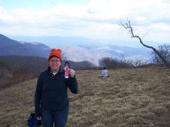
Mrs. Bolen with all her knew wisdom!
 Things are on the move here at Blue Ridge Middle School.  We had our first 4 Seasons Hiking Club hike to Sky Meadows State Park.  It was beautiful weather, about a 5.5 mile hike.  We have decided to try to do 4 hikes this year, and they are taking place on the weekends.  By having the hikes on the weekends, we are not responsible for providing transportation.  Students are also made aware that a parent must hike with them.  On our first hike we had about 8 students, each with a parent and about 7 teachers, and 3 dogs join us.  We are pictured here at the Paris overlook.  The students were great and excited to be there.  The parents were in awe of the view; we think we saw Reston/Tyson’s Corner or Washington DC from this vantage point.  On the way down, the students were asking when the next hike is going to be.
Little did they know, they next day in PE classes we were starting our orienteering unit.  The first and second day of the unit, we went over the parts of a compass and how to use it.  We gave the students some worksheets to label the parts of the compass, then in then we gave them time to work with their partners to find particular spots in the gym.  On the third day of our unit, we had the students break the speed record for hiking the Appalachian Trail.  We finished in 30 minutes!   Students were given background information on the trail and we pointed out particular points of interest and access points around us.  
Students were then broken into groups and given a pass card with 20 different points along the Appalachian Trail.  There were corresponding cones with punches and an exercise to complete throughout the gym.  We gave each group a starting point, they explored to find their spot, performed their exercises, punched their pass card and where on their way along the trail.  From a teacher standpoint it was really fun listening to groups wondering around the gym “Where is Clingmans Dome, I can’t find it!”, “How do I get to Old Blue Mountain?”  

We did not have the cones out in any particular order; they had to explore to find them.  When the students completed, we checked their pass cards (formative assessment!).

The next day, students watched a video to help them make a connection with what is around them.  We started with pictures from our outdoor classroom and expanded to pictures from our county, then pictures of faculty at Bears Den, Raven Rocks, Jefferson Rocks, Shenandoah River, and Furnace Mountain.  The video then goes into the entire trail, how it was developed and who maintains it.
 After that, students used posters we had hanging in the gym, they had to write 3 facts about the trail on the back of the card, then come up with a trail name and turn their postcard in to their teacher (another formative assessment!)
As a culminating activity, students participating in an orienteering course set up on our school property.  They are given compasses and coordinates.  Then they need to navigate to each flag and use the punches to punch their pass card.  We borrowed compasses from our high school so we can keep the groups small and each student will have the opportunity to use the compass.
This was a great unit, the students really enjoyed it.

Report on How Getting Dirty Outdoors Benefits Kids

From the National Wildlife Federation:
http://www.nwf.org/pdf/Be%20Out%20There/Dirt_Report_2012.pdf

These are some of the fun topics discussed:
Get the Dirt on Dirt:)
The Joy of Dirt
Good (Clean) Dirty Fun
Grime is Good


Thursday, November 7, 2013

Graphic Arts Unit: Leave No Trace or as one of my students said, “Don’t be Trashy, Be Classy!”

 Post by Lori DeMark Harmony Middle School

One of the things I take away from the TTEC pedagogy is how I can make an impact in my classroom with my students on a daily basis. What small step can I make that will impact the bigger picture? My Harmony colleague and TTEC partner, Nancy and I decided that we wanted the common thread through our curriculum and Harmony Hikes Club to be the Leave No Trace Principles. In the classroom we would focus on the principles that would impact our school environment and in the club we would focus more regionally with the Appalachian Trail.


I introduced my 8th grade art students to the Leave No Trace Principles. We compared being on the Appalachian Trail with walking down our school hall or being in the cafeteria. What principles could we address in our school community? We narrowed the seven principles down to two, “Trash Your Trash” and “Leave It as You Find It.”

My students had previously completed a Typography Unit and had a great base to build on for our Graphic Arts Leave No Trace Poster Design. First, we brainstormed possible phrases and images students could use in their design , then students created a rough draft of their idea, we discussed their designs, and refined their text, images, and layout before they created their final design.
7th grade art students were also introduced to the Leave No Trace Principles, they also worked on a graphic arts unit. Their end result was to create a Leave No Trace inspired button. Students worked through design sketches involving typography and layout before creating their final design. As part of American Education Week (November 18-22), students will wear their buttons at school to kick off our school wide Leave No Trace campaign.  After the poster designs and buttons were completed students in 7th and 8th grade completed a rubric and art statement as a reflective assessment of their work.
8th Grade LNT posters are displayed throughout the school and one design from each class was selected for enlargement to display in our cafeteria. Now we begin our environmental stewardship campaign. In addition to displaying posters in our school, we will display posters at the AT kiosk at Bear’s Den, Bluemont , VA. Artwork should be installed before the end of November.
Thank you TTEC for the inspiration!

Monday, November 4, 2013

A Place in History

Post by Rebecca Neet 
When I began designing my TTEC unit, I kept coming back to the idea of historical landmarks along the AT, but I also wanted to connect my idea to place based learning.  We are lucky in our area to have the Housatonic River running through not only our town, but the neighboring towns north and south as well.  So soon it wasn’t just about the historical landmarks along the AT, but the historical landmarks along the river as well, the same historical landmarks that tell the history of our area.  I began immediately developing partnerships with the local historical societies; Housatonic Heritage, the Sheffield Historical Society and the Great Barrington Visitor’s Center.  From there our initial outing was born; a two part field trip within downtown Great Barrington.  Working with Housatonic Heritage and spending some time taking the Great Barrington walking tour myself, we developed a walking tour along the Great Barrington Riverwalk and a quest for my students of local historical monuments within Great Barrington.  The outcome…success!  The students loved working on the quest, which challenged them to view buildings and historical markers as a means to answer their clues.  In addition, they came away with an excitement to show their families all they had learned about the Riverwalk.  Those who were unable to finish the final quest challenge continued it in class the following day and wouldn’t stop until they had discovered the final answer. 
That being the first step, the students then chose landmarks from along the river to research for our
“museum exhibit” which will be hosted through the Sheffield Historical Society and possibly the Berkshire Museum.   While researching, and to further tie the AT and the Housatonic to their history, I then worked to take all 45 fifth graders out onto the trail to hike.  Traveling in homeroom groups of 15, the students were challenged to view the hike as explorers seeing this land for the first time.  They made observations, took notes, shared ideas and then discussed upon our return whether or not this land would be good to colonize.  It was impressive to see all my students, writers and non-writers alike making notes and discussing with one another their ideas while we hiked the 3.5 miles over June Mountain and along the Housatonic.  All in all 43 of the 45 students of varying abilities and needs were able to hike and everyone enjoyed it!

What now you might ask.  Well, my next step is to help the students develop their exhibit pieces which will include an exhibit tag, a landmark pamphlet and a multi-media piece.  The students will then exhibit those pieces for the community.  And this spring, the students will create a 5-10 piece exhibit on the landmarks along the AT.  This will, again, include all the pieces described above, but will focus on those historical landmarks along the AT.  It will be interesting to see just how the program develops over the coming months.  I will keep you posted!

North Carolina NCCAT participants

North Carolina NCCAT participants
At the Wayah Bald Fire Tower

Mary Jane

Mary Jane
On top of Silers Bald